
4 Stages of Using GIS Cloud in Disaster Management
We have been trying to accurately predict disasters for decades. Starting from weather predictions to years-long climate changes, technology has come a long way. With the help of GIS mapping tools, we are able to accurately predict and mitigate natural disasters. In recent years, with the emergence of cloud technology, GIS cloud in disaster management is even more efficient and easy.
So how are these GIS cloud tools helpful? How can we use the GIS cloud in disaster management and disaster recovery? How can we strengthen our response to climate change and natural disasters as a community, as a city, and as a country?
In this blog, we detail it all. But first, let’s understand what is GID cloud briefly.
What Is GIS Cloud?
For the first time, a GIS solution is available solely through the web and is driven entirely by cloud technology. Full web-enhanced desktop GIS functionality is provided. With GIS Cloud, you can quickly and easily visualise, analyse, and explore your geographic data.
The primary aims of the GIS Cloud platform are to facilitate easy analysis of geographical data for users anywhere and to facilitate easy exchange of geographical data between users.
The capabilities of desktop GIS, such as geospatial analysis, spatial intelligence, the generation of individualised mapping reports, and the publication of geographic analysis, are available at your fingertips with GIS Cloud.
How To Use GIS Cloud In Disaster Management?
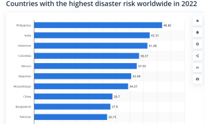
Countries with the highest risk of disasters in 2022. Source: Statista
Every year, millions of people around the globe are affected by climate change, natural disasters, pandemics, and artificial calamities. India is the 9th most vulnerable nation in the world to disasters. In fact, according to World Index, India has 42.31% disaster risk worldwide. Moreover, 27 of India’s 36 states and union territories are vulnerable to natural disasters.
Geographic information system (GIS) technology has allowed India to make great strides in catastrophe prediction in recent years. Modelling disaster risks and human responses to hazards is greatly aided by GIS technology. Furthermore, using GIS cloud in disaster management proves to be a decision-making tool for emergency managers.
With the help of predictive tools, we can manage disaster planning and recovery. There are 4 stages of disaster management starting from preventive measures to recovery. Here is how GIS Cloud tools effectively manage all the stages of disaster management.
Stage 1: Mitigation
Mitigation measures are essential to avoid casualties and property losses during natural catastrophes. The Federal Emergency Management Agency (FEMA) collaborates with local governments, states, and indigenous tribes to coordinate short- and long-term disaster management plans.
It is possible to use GIS software to update flood hazard mapping to build a Risk Map program. These dynamic, up-to-date maps can illustrate areas with a risk of flooding. Since the maps may be updated as environmental conditions change, FEMA may publicly share them to support current and successful emergency management strategies.
Stage 2: Preparedness
The locations most likely to be affected by a hazard can be predicted by appropriate authorities using GIS technology. Geodata from different periods can be used to forecast changes in an area and analyse past changes. When an emergency strikes, this will inform authorities where to concentrate their resources and workforce.
Stage 3: Response
The availability of crowdsourced (community-shared) geospatial data makes it simpler to complement reliable sources as technology advances. What highlights the significance of GIS tools is how time-sensitive the problem is.
Geodata sharing platforms, like Ellipsis Drive, allow local disaster management teams to quickly and efficiently communicate location-specific data with them. Time is the main asset in this situation. Saving a few precious seconds can mean the difference between life and death.
Stage 4: Recovery
After a calamity, it’s common for the affected areas to be off-limits. Obtaining factual numbers of affected people on the ground is impossible. As a result, this has an impact on the decision-making process.
Using GIS tools and location intelligence, disaster management teams can construct an organised list of locations to recover from and rebuild based on priority and impact severity.
Wrapping Up
Using forecasts or risk zone maps (made possible by GIS technology) allows for early detection of impending calamities. In a disaster, a database of all the people who need help is created using GIS technology for disaster management.
Medical facilities, homeless shelters, and other resources are all listed in the emergency database. Maps depicting the likelihood of or damage from disasters emphasise preventative measures. Thanks to these benefits, handling disasters and crises is easy with GIS.